Property Record
1167 Highway 77, Bridgeton, NJ 08302
NEARBY LISTINGS FOR SALE OR LEASE
Property Detail
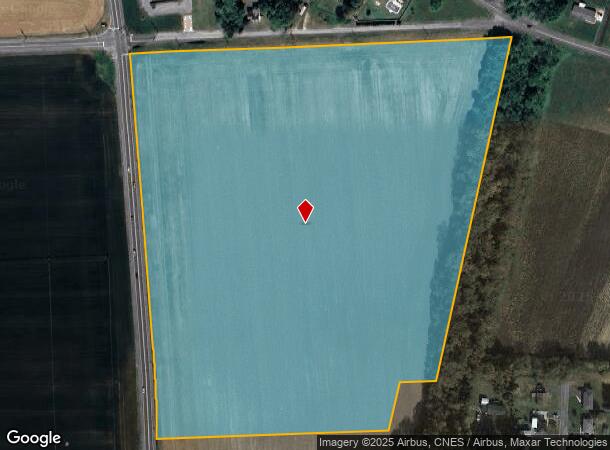
1167 Highway 77
13-01206-0000-00001-01-QFARM
Cumberland
Farms
New Jersey
X
1.1
34011C0155E
34.52 AC
2024
Vineland/Bridgeton
2025
Philadelphia
010701
Vineland-Bridgeton, NJ
DEMOGRAPHICS near 1167 Highway 77
1 Mile
3 Mile
5 Mile
2024 Total Population
990
13,700
39,988
2029 Population
972
13,519
39,386
Pop Growth 2024-2029
(1.82%)
(1.32%)
(1.51%)
Average Age
44
37
36
2024 Total Households
406
4,542
12,958
HH Growth 2024-2029
(1.97%)
(1.41%)
(1.54%)
Median Household Inc
$79,375
$58,699
$55,200
Avg Household Size
2.40
2.90
2.90
2024 Avg HH Vehicles
2.00
2.00
2.00
Median Home Value
$201,562
$209,213
$193,266
Median Year Built
1969
1969
1965
Nearby Places
Map Layers
Map Styles
 Street
 Aerial
- Restaurants
- Banks
- Shops
- Fitness
- Groceries
PUBLIC TRANSPORTATION
AIRPORT
Philadelphia International
DRIVE
WALK
Distance
Philadelphia International
62 min
38.0 mi
Freight Ports
Port of Wilmington, RI
DRIVE
WALK
Distance
Port of Wilmington, RI
46 min
32.9 mi
SALE & LEASE HISTORY
LISTING DATE
SALE/LEASE

Sep 24, 2016
For Sale
Nearby Properties
Address
Land Use
TOTAL SIZE
Lot Size
Zoning
Address
Land Use
TOTAL SIZE
Lot Size
Zoning
140.15 AC
R1
Address
Land Use
TOTAL SIZE
Lot Size
Zoning
3.19 AC
Address
Land Use
TOTAL SIZE
Lot Size
Zoning
52,724 SF
3.32 AC
Address
Land Use
TOTAL SIZE
Lot Size
Zoning
16.23 AC
Address
Land Use
TOTAL SIZE
Lot Size
Zoning
29.17 AC
B2
Address
Land Use
TOTAL SIZE
Lot Size
Zoning
32.89 AC
GI
Address
Land Use
TOTAL SIZE
Lot Size
Zoning
9.64 AC
P
Address
Land Use
TOTAL SIZE
Lot Size
Zoning
32.57 AC
GI
Address
Land Use
TOTAL SIZE
Lot Size
Zoning
12.42 AC
Address
Land Use
TOTAL SIZE
Lot Size
Zoning
23.50 AC
P
Address
Land Use
TOTAL SIZE
Lot Size
Zoning
22 AC
B2
Address
Land Use
TOTAL SIZE
Lot Size
Zoning
13.67 AC
B2
Address
Land Use
TOTAL SIZE
Lot Size
Zoning
97,112 SF
Address
Land Use
TOTAL SIZE
Lot Size
Zoning
19.95 AC
Address
Land Use
TOTAL SIZE
Lot Size
Zoning
13.94 AC
Address
Land Use
TOTAL SIZE
Lot Size
Zoning
13.46 AC
B-2
Address
Land Use
TOTAL SIZE
Lot Size
Zoning
9.17 AC
R2
Address
Land Use
TOTAL SIZE
Lot Size
Zoning
6.70 AC
Address
Land Use
TOTAL SIZE
Lot Size
Zoning
4.20 AC
R2
Address
Land Use
TOTAL SIZE
Lot Size
Zoning
5.38 AC
R2
Address
Land Use
TOTAL SIZE
Lot Size
Zoning
69.36 AC
Address
Land Use
TOTAL SIZE
Lot Size
Zoning
13.21 AC
B2
Address
Land Use
TOTAL SIZE
Lot Size
Zoning
53,518 SF
Address
Land Use
TOTAL SIZE
Lot Size
Zoning
116.91 AC
GI
Address
Land Use
TOTAL SIZE
Lot Size
Zoning
53,792 SF
R2
Address
Land Use
TOTAL SIZE
Lot Size
Zoning
26.08 AC
GI
Address
Land Use
TOTAL SIZE
Lot Size
Zoning
6.73 AC
P
Address
Land Use
TOTAL SIZE
Lot Size
Zoning
48.66 AC
P
Address
Land Use
TOTAL SIZE
Lot Size
Zoning
5,324 SF
3.94 AC
B2
Address
Land Use
TOTAL SIZE
Lot Size
Zoning
2,019 SF
2.43 AC
B2
The World's #1 Commercial Real Estate Marketplace
Connect with us
© 2025 CoStar Group
The information above has been obtained from sources believed reliable. While we do not doubt its accuracy we have not verified it and make no guarantee, warranty or representation about it. It is your responsibility to independently confirm its accuracy and completeness. Any projections, opinions, assumptions, or estimates used are for example only and do not represent the current or future performance of the property. The value of this transaction to you depends on tax and other factors which should be evaluated by your tax, financial, and legal advisors. You and your advisors should conduct a careful, independent investigation of the property to determine to your satisfaction the suitability of the property for your needs.